The core of the Memorial is in the first volume, which marshals the facts with the 1982 UN Convention on the Law of the Sea (UNCLOS) and customary international law. It combines analysis with advocacy in order to persuade the tribunal to rule in the Philippines’ favor, and declare China's Nine Dashed Line claim invalid and hold that China should end its illegal occupation of eight rocks and reefs in the West Philippine Sea.
The Memorial faces at least two major hurdles, each of which must be surmounted convincingly in order to persuade the tribunal to rule on the case on the merits. Both impinge on the jurisdiction of the ad hoc tribunal, which was constituted in accordance with Article 286-288 (compulsory procedures in cases of disputes over the interpretation and application of the treaty) and Annex VII (basic procedures for the establishment of arbitral tribunals) of the UNCLOS.
Non-participation of China
First is the absence of China from the proceedings. There are substantive and procedural questions that revolve around whether or not a party that has rejected and does not participate in the arbitration can be bound by its decision.
The international maritime case law on such a situation is still relatively sparse, with only two decided maritime boundary delimitation cases so far: Guyana v. Suriname and Barbados v. Trinidad and Tobago. However, in both cases, the defending party did participate in the proceedings. Suriname contested the tribunal's jurisdiction, but conceded that if certain facts were established then it could exercise jurisdiction. Trinidad and Tobago, on the other hand, contested jurisdiction but at the same time made counter-claims against the opposing party, which implied that it also accepted jurisdiction. Therefore, the two cases are not directly comparable to the situation of the Philippines-China arbitration, where the defending party has completely refused to participate at all.
However, the Philippines is confident that China's non-appearance and non-participation does not bar the arbitration. An applicant-State's right to unilaterally bring a dispute to arbitration over the defending-State's objections was also expressly recognized in the Barbados case, which means that on this point, the only aspect possibly in favor of China is its total absence from the case.
From a substantial perspective, China’s non-participation brings to the fore the essence of arbitration that distinguishes it from adjudication, that is, there has to be consent from the disputing parties. This presents the Philippines with a possibly trend-setting challenge: It must persuasively argue that the ruling in the Barbados case recognizing the applicant's right to unilaterally bring a dispute to arbitration still holds true despite such absence.
Claim to West Philippine Sea
The second major obstacle is the tribunal's appreciation of the nature and substance of the dispute.
China's most plausible arguments against the arbitration are:
(a) It is an attempt to indirectly secure the Philippines’ claim to the different islands, rocks and reefs in the West Philippine Sea, as the competing claims to sovereignty over them are the actual core of the disputes; and
(b) The Philippines is asking the tribunal to rule on the legal status of China's actions and installations in the West Philippine Sea, which cannot be done unless the tribunal undertakes maritime boundary delimitations to determine who has the right to exercise sovereignty or jurisdiction in the parts of the seabed on which they are located.
These objections are based on conventional practice whenever an international tribunal is asked to determine which coastal State has sovereign rights over portions of their adjacent or opposing seas. Typically, the tribunal must first assure itself of which coastal State has sovereignty over any relevant land masses, measure and project the corresponding maritime zones from them, and in case they overlap, delimit the boundaries between the disputing States, before it can characterize the legality of acts in any specific location.
If the tribunal accepts the Chinese viewpoint, then it will decline jurisdiction over the Philippines' claims.
In the Memorial, the Philippines will attempt to sidestep these defenses by insisting that it does not seek either a determination of sovereignty over the islands, or a delimitation of maritime boundaries. It must show that the conventional practice of international courts does not apply in this case.
Focus on Nine Dashed Lines
However, simply stating that a decision on sovereignty is not sought, or that boundaries need not be delimited, will not be enough: the tribunal needs to be absolutely convinced that these are not necessary to the resolution of the issues under arbitration. These may be addressed by zeroing in on the principal source of the disputes, which is the Nine Dashed Lines.

The Nine Dashed Lines represent China's claim to certain amorphous rights – characterized as such because they have not had any clear substantive basis for decades –within a vast expanse of the South China Sea. It is this lack of clarity that has been China's main refuge for attempting to reserve and assert its claims anywhere within this large body of water.
Since 1947, China's diplomatic communications described its claim as sovereignty over the islands and insular features, not the entirety, of the South China Sea. Mainland China never took action to assert this amorphous claim, although Taiwan independently took control of the largest island, Itu Aba. Neither the mainland nor Taiwan explained the basis or substance of the claim, but among Chinese scholars and policy advocates, the explanation of the Nine Dashed Lines is split into four:
- It represented a claim to sovereignty over only the islands (not waters) within the lines.
- It was a claim to sovereignty over islands and UNCLOS-based jurisdictions over the enclosed waters.
- It represented a line of historic rights to fishing.
- It represented a historic territorial boundary line.
Lack of clarity on the real nature of the Nine Dashed Lines allowed China's actions to be sheltered within the plausible limits of interpretation under UNCLOS. This policy of ambiguity prevailed until sometime around 2008-2009, when China became increasingly assertive in its maritime policies and enforcement activities in the aftermath of the Vietnamese and Malaysian claims to the seabed beyond 200 nautical miles in the South China Sea, in accordance with UNCLOS.
China’s actions inevitably led to conflict, as the Nine Dashed Lines effectively deprived other countries around the South China Sea of their own exclusive economic zones (EEZs) and continental shelf under UNCLOS. Not only did China begin sending its law enforcement vessels to protect Chinese fishing operations inside the EEZs of Vietnam, Indonesia, Malaysia, and the Philippines, it also began actively interfering with their long-standing petroleum exploration activities. Chinese ships cut the seismic exploration cables of Vietnamese survey ships, and threatened the operations of Philippine vessels off Reed Bank. China also protested Philippine petroleum contracts and bidding processes for concession areas on the Philippine continental shelf off Palawan.
These acts were undertaken in places where they could not be justifiable unless China was claiming to exercise absolute sovereignty over the entire area of the Nine Dashed Lines, which was inconsistent with its previous public positions.
China's diplomatic language also increasingly bent toward claiming absolute sovereignty on the basis of history, not international law. However, this flies in the face of both UNCLOS, which establishes the system of maritime zones globally, and customary international law, which has consistently held for hundreds of years that no State can place any portion of the high seas under its sovereignty.
Prospective vs. territorial claim
The basis for China's strength in the past is also its greatest weakness at present: legal ambiguity and coercive action fundamentally create a situation of inequity. The Philippine Memorial may exploit this weakness by impressing upon the tribunal the idea that the Nine Dashed Lines can only be interpreted as a prospective Chinese claim to UNCLOS maritime zones, rather than a territorial claim. This means it can only be appreciated as an attempt to delineate a maximum negotiating position for UNCLOS-based maritime zones, not as a defined boundary, and cannot unilaterally create enforceable rights.
The Philippines could harp on China's lack of clarity as preventing the emergence or recognition of any maritime rights in its favor, and then invoke estoppel by emphasizing Chinese statements that are more susceptible to an interpretation consistent with UNCLOS. Such statements can be used as binding declarations against China’s interest regarding its current expansive claims to the South China Sea.
By binding China to an UNCLOS-based interpretation of the Nine Dashed Lines, the excessive character of the claim and the acts undertaken by China to assert it are clearly demonstrated. Such an interpretation will also test the Nine Dashed Lines against the standards for measurement of maritime zones as defined in UNCLOS, which in turn will determine where China can legitimately lay its claims. It will then enable a proper determination of whether or not historic title, rights, or waters concepts may properly be invoked in China's favor in the South China Sea.
It is expected that the Philippines will question whether or not claims to waters based on history survived the processes of negotiation, ratification, and entry into force of UNCLOS. On this issue, the Philippines definitely has the upper hand, as maritime international scholars agree that expansive claims to marine waters based on history were practically and deliberately eliminated by UNCLOS, save for a few instances applicable only to the internal waters and territorial sea not exceeding 12 nautical miles from shore, and limited recognition of traditional fishing rights in the EEZ.
The necessary proof will probably center on publicly known events, such as China's interference with navigation and seismic survey activities, pressure against Philippine petroleum exploration, and protection of illegal fishing activities well beyond any possible hypothetical EEZ or continental shelf boundary line. China's interference can only be based either on a claim to sovereignty over the area within the Nine Dashed Lines, or a claim to the exercise of sovereign rights (including legislative, regulatory, and enforcement jurisdiction) under international law.
In either case, none of these activities at the periphery of the Nine Dashed Lines can be justified. They would persuasively demonstrate their own excessiveness, even without any possible maritime delimitation. The Philippines can show that there is no plausible delimitation solution for the incidents shown, and therefore, the issues raised cannot be questions of maritime boundary delimitations.
Thus, it may be argued that these are purely questions of application and interpretation of UNCLOS, well within the jurisdiction of the arbitral tribunal.
Questionable Chinese installations
An extensive and successful demolition of the Nine Dashed Lines will undermine China's legal positions with respect to its artificial islands and installations in the West Philippine Sea. These installations are of two kinds:
(a) those established on submerged reefs like Mischief Reef, and
(b) those built on reefs that originally had rocks above water at high tide, like Fiery Cross Reef.
China built structures on reef atolls in order to take advantage of the natural harbor that the reef offers in what would otherwise be open sea. They serve as ideal offshore bases, supply stations, and shelters for all types of vessels.
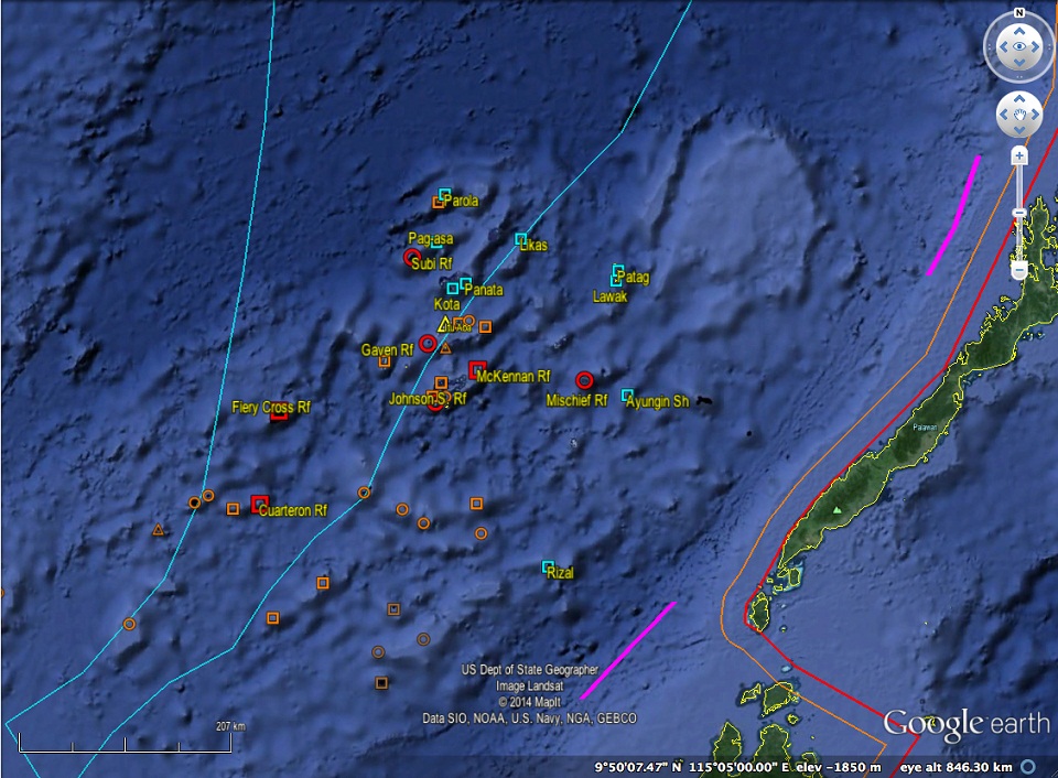
The Chinese installations on Subi, Gaven, McKennan, and Mischief Reef run afoul of international law because they are obviously artificial islands built on the submerged seabed. International law does not recognize any maritime entitlements arising from such facilities, as submerged reefs are simply part of the seabed or continental shelf. Fiery Cross, Cuarteron, and Johnson Reef are also artificial islands, but the presence of rocks at high tide on those reefs at least establishes a 12-nautical mile territorial sea around them. Scarborough is similarly situated, having several rocks above water at high tide, although occupation and control of the reef is exercised through the stationing of Chinese maritime law enforcement vessels rather than through construction and maintenance of facilities.
The Philippines will argue that by impeding navigation or scaring away Philippine fishing and other resource activities in the areas around these features, China is asserting excessive maritime rights. It can be expected that the Philippines will introduce much technical evidence to prove the nature of these features, and compare them with similar features elsewhere that have already been characterized by courts or arbitral tribunals.
The recently concluded Nicaragua v. Colombia is likely to be invoked by the Philippines, since it dealt squarely with questions of the physical characteristics of rocks and islands and entitlement to maritime zones. For example, one rock in the Nicaragua case called Quitasueño was only the size of a small closet rising one meter above water at high tide, and generated only a 12-nautical mile territorial sea; it bears a striking resemblance to the rocks in Scarborough Shoal. Since Quitasueño has been adjudged to represent a “rock” under Art. 121(3), then similar features should be similarly classified.
The Memorial will surely include evidence of the acts of China that represent its excessive assertions of sovereignty or rights. These include its interference with Philippine fishing activities and navigation to and from the Kalayaan Island Group, protests against petroleum exploration in the contract areas west of Palawan (including Reed Bank), and possibly its coercive protection of Chinese fishing activities deep inside the Philippine EEZ. News reports are not enough, so the evidence in the annexes will probably include official records, reports, and other documents about these events.
Resolving political geography
One of the greatest and most obvious challenges to getting the tribunal to rule favorably on these claims against the Chinese installations is the legal implication of the presence of other islands and rocks in their vicinity.
As stated in the North Sea Continental Shelf cases, there can be no question of refashioning nature or geography in the determination of maritime entitlements. This will prompt the tribunal to seek full knowledge of the context of the contested features and facilities; once they appreciate the complicated natural and political geography of the area, they will most certainly question whether the location of the Chinese installations are such that they may be within the prospective maritime zones of any other island or rock whose ownership and status of sovereignty may be questioned.
Various such features are present within the vicinity of the Chinese installations. The most notable are the two largest islands – Itu Aba occupied by Taiwan, and Pag-asa Island occupied by the Philippines. Even if a decision on the sovereignty of those islands is not sought, the fact that an installation may be within 12 nautical miles of an island or rock means that the tribunal cannot determine the legal status of the seabed on which the Chinese installation is built, without a ruling on sovereignty and a maritime boundary delimitation.
Thus, the Memorial must persuasively argue that the presence of these adjacent features has no relevance to the determination of the legal status of China's occupation at each location. Extended arguments about each one can be expected, so that the tribunal can make individual determinations.
Jurisdiction in conclusion
Solicitor General Jardeleza, in a recent UP forum, hinted at how the Memorial will end: by tackling the jurisdictional objections in conclusion, not as a preliminary issue. The advantage of this strategy is that the Philippines will have the opportunity to present the case in full, and thus ensure that the merits are heard, before the tribunal decides whether or not it should exercise jurisdiction.
The procedure adopted by the tribunal does not separate the resolution of the issue of jurisdiction from the decision on the merits. The Memorial will likely be similar in structure. This way, it is hoped the tribunal will see the merits of the case and find that regardless of the forms, procedures, and technicalities, there is an undeniable need to dispense justice and establish the basis for fairness in the maritime relations between the Philippines and China. - YA, GMA News
~GMA News


No comments:
Post a Comment